Pangea
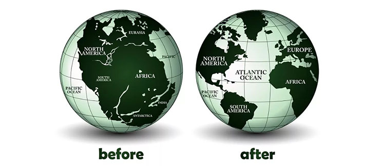
A grandiose event took place about 150 million – 220 million years ago, when the supercontinent Pangea, washed by the Panthalassa Ocean, split into two parts – northern (Laurasia) and southern (Gondwana).
But the continent of Pangea at one time, about 350 million years ago, arose from the collision of two continents – the same Laurasia and Gondwana, into which it later broke up. In the places of this collision, two ancient mountain systems appeared – the Urals and the Appalachians, which were then much higher than today. However, the crash did not end with the collision: the counter-movement of the lithospheric plates continued.

The supercontinent Pangaea in the early Mesozoic (at 200 Ma) Credit : Wikipedia
Such powerful resistance from the two continents caused such enormous tension in the center of the new continent they created that the earth’s surface could not stand it and arched into a new mountain range. This was the beginning of the end: the tension grew further, and Pangea could not withstand it—the attempt to absorb itself ended in a new rift. We can say that no Pangea existed; just Laurasia and Gondwana fought for 200 million years and then broke up again.
There is a theory according to which approximately once every 500 million years, all continents gather into one supercontinent. So we have about half of this time left before Eurasia, Africa, Australia, Antarctica, and the Americas merge into Pangea Ultima. The directions of movement of the continents currently recorded indicate that this will be the case.
Gondwana
The reasons were varied – from overheating of the mantle, which caused the movement of tectonic plates, to the collision of the planet with a meteorite that fell precisely in the center of the giant continent.

Gondwana, also called Gondwanaland, was the ancient supercontinent that consisted of present-day Africa, Arabia, South America, Madagascar, Sri Lanka, Australia, India and Antarctica. Credit: WIKIMEDIA COMMONS/HOWSTUFFWORKS
About 120 million years ago, a new upward flow of mantle material tore Gondwana approximately along the boundaries of the protocontinents that formed it 600 million years ago.
Almost simultaneously, the split of Eastern Gondwana began when Madagascar and Hindustan separated. It is believed that this continental breakup occurred during the passage of East Gondwana through the Kerguelen hotspot. Those. It is possible that the hot mantle jet, now located in the Kerguelen Island area, caused East Gondwana’s breakup.
During this same period, the separation of Australia from Antarctica began, slowly developing over 25 million years, until 45 million years ago, when eastern Australia separated from Antarctica. After this, Australia quickly rushed to the north and Antarctica – to the south.
Finally, the last act of the split of Gondwana occurred approximately 30 million years ago. At this time, South America lost contact with West Antarctica, and the Arabian and Somali plates separated from Africa. Large outpourings of basaltic lavas did not cause major extinctions this time. But the volumes of erupted lava suggest the presence of mantle flows that melted the continent’s base.
Pangea-Gondwana gap hypothesis
Suppose a stream of hot magma, in its upward movement, encounters a massive continental crust 30 to 70 kilometers thick. In that case, it behaves differently than when it hits the oceanic crust, which is only 5-10 kilometers thick. In the ocean zone, the heat that magma carries with it is absorbed by the crust and ocean water. Heat accumulates under the continents, where the crust is several tens of kilometers thick. And it begins to act on the bark from below, much like a gas cutter on metal: it melts and cuts it into pieces. Magma flows in their movement, takes these parts of the continent with them, and separates them from each other.
Continental drift

Credit: MAP BY USGS
Today, every schoolchild knows that seemingly motionless continents and islands are in continuous motion. Proper, the continents do not wander independently, as was imagined by the German geophysicist Alfred Wegener, the author of the first scientifically developed hypothesis (1912) of continental drift. They move along with the adjacent areas of the ocean floor.
The force driving the giant plates is the upward flow of molten magma, which is heated in the deep layers of the Earth. Rising upward, the streams encounter the lower surface of the earth’s crust. At the same time, they diverge and drag the tectonic plates lying above them in different directions. The entire earth’s crust consists of such plates. It turns out something like a moving mosaic. Its fragments collide, and one plate sinks under the other – “submerges.”
Measurements taken from satellites showed that the continents move on average not 1-5 centimeters per year, as previously thought, but much faster. For example, southern Latin America is moving toward the Pacific Ocean at a rate of 17 centimeters per year.
Where does the now unnecessary ocean floor go?

Credit: Encyclopædia Britannica, Inc.
At first, when seismological surveys showed that subducting plates at a depth of about 670 kilometers were breaking apart as if they had encountered a massive “wall,” many researchers took this as the final answer to the question. Using a computer model, Professor of the University of Göttingen U. Christensen showed that the relatively cold stone parts of the slabs actually remain at a certain depth at the beginning of the dive but then begin to sink again slowly.
Seismic tomography also showed that at least part of the subducted plate breaks through the “wall” at 670 kilometers and sinks below. Several scientists are of the opinion that the former ocean floor goes to a depth of 2,900 kilometers – to the boundary between the mantle and the outer core of the planet. There, “heaps” from 200 to 400 kilometers thick are deposited from this material. On the outer core, washed by convection currents of magma, there are stagnant places where material coming from above is collected.
Geologists call these places “slab graveyards” because sunken rock can lie there for billions of years until a rising convection current carries the material back up.
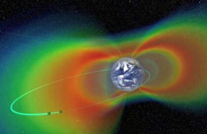
Earthquakes and solar activity?
During solar activity, more complex processes occur in the Earth’s core. Due to the flow of solar cosmic rays, ionospheric currents increase, and the variable component of these currents induces Foucault currents in the earth’s core. The energy pumped into the planet in this way melts part of the core, increasing the volume (thereby changing the rotation and shape of the Earth, as well as pressure) – an earthquake occurs.
But each region of the Earth has its reaction. Unlike terrestrial events associated with solar activity, intraterrestrial events occur with some delay. One of them is a slowdown in the Earth’s rotation speed. It has been noted that the maximum activity of volcanoes lags behind solar activity by about one year. Moreover, the strength and duration of terrestrial activation (catastrophes) are directly proportional to the solar one. This is true for all latitudes and longitudes of the Earth.
Banner image: robin2/Shutterstock
Image credit:
https://www.wondriumdaily.com
https://en.wikipedia.org
https://science.howstuffworks.com
https://education.nationalgeographic.org
https://ww w.britannica.com