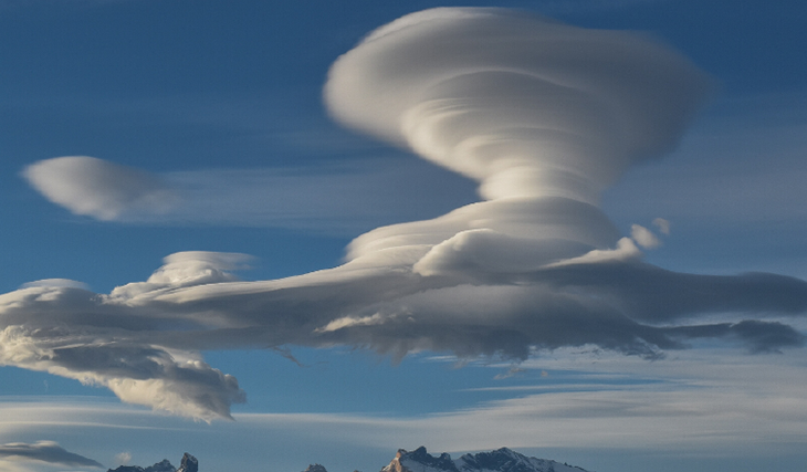
An average-sized cloud weighs about ten tons, and the height of large thunderclouds can reach ten kilometers.
The formation of clouds is associated with warm air rising and cooling in the atmosphere and is not without dust and smoke. Water vapor moves upward and condenses around these particles. The absence of these elements causes the cloud to dissipate. In low-humidity conditions, the lifespan of a cloud can be only 15-20 minutes.
Some clouds form only when many conditions are met, so that they can be observed rarely, and only if you are lucky.
Lenticular cloud
A lenticular cloud, similar to a lens or a stack of pancakes, is formed when strong winds encounter a tall obstacle, such as a mountain or building.
A lenticular cloud was spotted over Bursa, Turkey, on Jan. 19, 2023. Credit: (@firuzedr16 via SPECTEE /TMX / FOX Weather
As the air rises, it cools and condenses into a flat cloud above the obstacle. Even when it appears stationary, the cloud is in constant motion, creating wave-like oscillations in the air. Cloud physicist Patrick Chuang explains this phenomenon with the analogy of driving a recumbent police car over a Cadillac, causing it to oscillate up and down over some time.
Lenticular clouds can be observed over high obstacles such as mountain peaks. Lenticular clouds are rare and are observed mainly in mountainous areas. Most often, they are recorded in the USA, Kamchatka, and the area of Mount Fuji in Japan.
Fallstreak Hole
A Fallstreak Hole is a rare meteorological phenomenon that appears as a round or elliptical hole in the clouds.
A fallstreak hole forms when part of the cloud layer forms ice crystals. Credit: GOFF/BBC
It occurs when water droplets in clouds freeze at low temperatures but do not form ice crystals. Evaporated supercooled water droplets leave behind these holes in the clouds. Various factors, such as the aircraft or changes in pressure and temperature, can cause their occurrence. Hole punch clouds are a rare phenomenon that can only be observed under certain weather conditions.
Kelvin-Helmholtz cloud
A Kelvin-Helmholtz cloud is an atmospheric phenomenon with wave-like formations named after the scientists Lord Kelvin and Hermann von Helmholtz.
Sky-watchers in the US state of Wyoming. Credit: FACEBOOK/ RACHEL GORDON
It occurs when the upper, less dense layer of matter moves faster than the lower one. The dynamics of this movement determine the similarity with ocean waves. The instability between the layers leads to lifting the upper edge of the lower layer, which leads to a wave-like failure. Pilots are advised to be prepared for turbulence if Kelvin-Helmholtz clouds are encountered during flight.
“Morning glory clouds”
A cumulus cloud is a low-level cylindrical cloud associated with thunderstorms.
Credit: Author Deborah Toop / Courier Mail
It occurs due to an inversion when warm air lies on top of cooler air, often indicating a thunderstorm. This cloud instability is often seen in cumulus clouds. However, they are rare except in Cape York, Australia, where they are called “morning glory clouds.” The reason for their constant occurrence remains a mystery, possibly related to sea breezes near the Gulf of Carpentaria and the Coral Sea.
Anvil cloud
An anvil cloud is a variant of a cumulonimbus cloud with a flat top in the shape of an anvil
Credit: Ginger Robinson / Flickr
Formed when ascending air reaches the tropopause and moves horizontally, leading to an “incus” or overshoot top in the stratosphere, heralding a severe storm.
Asperitas cloud
An asperitas cloud is a new atmospheric phenomenon proposed by Gavin Praetor-Pinney and later recognized by the World Meteorological Organization.
Asperitas clouds loom over Lake Ontario on Tuesday. Credit: James Montanus/ Washington Post
The name comes from the Latin word “asperitas,” which means “roughness”. These clouds are formed by the breakup of a stable lateral cloud in several directions, often during the approach of a storm.
Pearl cloud
The term “pearl cloud” describes clouds that glow with a pearly sheen.
Credit: Author S.By /SRB
They can take many forms, including layered cumulus, high cumulus, and pinnate cumulus. This glow is caused by the reflection and refraction of sunlight by water droplets or ice crystals.
Nacre clouds, also known as polar stratospheric clouds, form in the stratosphere during a sudden drop in temperature. They can be observed in the Arctic and Antarctic, where ice crystals diffract light waves, creating a spectacular color ledge in the sky.
Mammatus clouds
Mammatus clouds are a unique type of cloud that usually occurs during an unstable atmosphere, especially during thunderstorms.
These eerie mammatus clouds appeared over a high school graduation ceremony in Pekin, Ill., on May 22, 2011, as part of the tornado outbreak that produced the devastating Joplin tornado the same day. Credit: iWitness Weather/Candi Carter Kupris
Named after the Latin term “mamma,” meaning “chest” or “udder,” their formation is a matter of debate among scientists. One theory points to sublimation when ice crystals turn into water vapor directly. These clouds are usually seen after thunderstorm activity but can also occur in clear weather, exceptionally high cumulus, and cirrus clouds.
Clouds on other planets
Credit: CC0, via Pixabay
Clouds do not only exist on Earth. They were also recorded on Mars and Venus, Titan (a satellite of Saturn), and Triton (a satellite of Neptune). However, here, the clouds are entirely different.
For example, on Venus, the clouds are pretty dense and consist of sulfur dioxide and sulfuric acid droplets. They reflect about 75% of incoming sunlight and obscure the planet’s surface, preventing it from being observed. Due to the high thickness of the cloud cover on Venus, the illumination when the Sun is at its zenith is the same as on Earth on the cloudiest day, about 1000 lux. The clouds of Venus are capable of creating lightning in the same way as clouds on Earth.
On Titan, methane condenses into clouds at an altitude of several tens of kilometers. According to data obtained by Huygens, the relative humidity of methane increases from 45% at the surface to 100% at an altitude of 8 km (while the total amount of methane, on the contrary, decreases). At an altitude of 8-16 km, there is a very lofty layer of clouds consisting of a mixture of liquid methane and nitrogen, covering half of the satellite’s surface. Drizzle constantly falls from these clouds to the surface, compensated by evaporation.
In December 2006, Cassini again detected cloud cover over the pole. The cloud reached a diameter of 2400 km and was also observed on the next flight of the device a month later. According to observations from Earth, during one 30-year revolution around the Sun along with Saturn, clouds form on Titan in each hemisphere within 25 years and disappear within 4-5 years before appearing again.
On Triton, at a altitude of 1-3 km, there are nitrogen clouds with a length of about 100 km. The cloud temperatures are slightly higher than Triton’s surface temperature due to solar radiation and Neptune’s magnetosphere.
Banner image: Weather Gizmo
Image credit:
https://weather-aware.com
https://www.foxweather.com
https://www.bbc.com
https://www.bbc.com
https://www.couriermail.com.au
https://www.flickr.com
https://www.washingtonpost.com
https://seenorway.wordpress.com
https://www.thenakedscientists.com
https://weather.com


