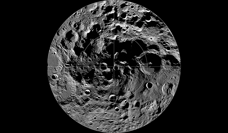
The Moon’s south pole shifted 5 degrees from its original position billions of years ago, changing the Moon’s rotation axis and exposing previously shadowed areas to sunlight. Despite this, there are still dark areas at the south pole, and conversely, there are places that are constantly illuminated by sunlight. The area contains many craters and depressions, including the South Pole-Aitken Basin, which is considered one of the key features of the Moon. Also prominent is a mountain such as Epsilon Peak, which stands at 9,050 m, which is higher than any mountain on Earth. The average temperature at the south pole is about 260 K (-13 °C; 8 °F).
Cold traps
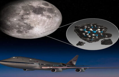
Cold PSR (permanently shadowed crater) traps at the lunar south pole contain water ice and other volatile materials originating from comets, meteorites, and solar wind exposure. Scientists have confirmed the presence of ice and hydroxyl in these traps based on experiments and samples. The ice remains trapped due to the Moon’s thermal behavior associated with thermophysical properties such as scattered sunlight, thermal radiation, internal heat, and light emitted by the Earth.
How was water found on the Moon?
In the 1960s, before the first Apollo mission, scientists suspected the possible presence of water on the Moon, but samples brought back by Apollo crews in the late 1960s and early 1970s were dry.
In 2008, researchers at Brown University, using new technology, discovered hydrogen in tiny beads of volcanic glass in lunar samples. The Chandrayaan-1 probe, launched by the Indian Space Research Organization in 2009, discovered water on the surface of the Moon. The same year brought another discovery: another NASA probe that impacted the moon’s south pole discovered water ice beneath its surface. In 1998, NASA’s Lunar Reconnaissance mission also confirmed that the highest concentrations of water ice are found in the shadow craters of the Moon’s south pole.
Chandrayaan-3
Chandrayaan-3 and the Pragyaan rover have sent us some interesting observations from the Moon. The rover moved some distance from its mother ship, moving at a speed of 1 cm (0.4 in) per second. The dusty surface temperature was around 50°C (120F). Temperatures dropped sharply just 80 mm (3 inches) below the surface. The rover measured it by plunging its probes into the ground. His chemical analysis equipment showed the presence of sulfur, aluminum, calcium, iron, titanium, manganese, chromium, and oxygen in the lunar soil.
Thanks to the Moon’s shallow rotation axis (1.5 degrees; Earth’s 23.5 degrees), many craters at its poles never receive sunlight. Combined with low temperatures, this creates the conditions for an abundance of ice, much of which is below the surface or mixed with the soil. This ice could become an important resource for future astronaut missions and scientific research.
South Pole Resources
Chandrayaan-3 confirmed the wealth of resources in the south-polar region of the Moon. This place is rich in solar energy, oxygen, and metals. Placing a facility for the extraction and processing of lunar resources near the south pole will create the possibility of continuous operation of a power plant powered by solar energy. A variety of elements have been found on the surface of the Moon, including hydrogen, oxygen, silicon, iron, magnesium, calcium, aluminum, manganese, and titanium. Among them, oxygen, iron, and silicon are the most abundant, with oxygen making up an impressive 45% of the mass of discovered resources.
The dangers posed by the South Pole
Attempts to land on the Moon have previously met with failure. The Russian Luna 25 attempted to land at the South Pole but lost control and crashed on August 19, 2023. This region, unlike the equatorial zones where previous missions were conducted, is full of craters and deep fissures.
The Moon’s south pole may contain water ice due to its shady nature, but a soft landing here is extremely difficult. Most vehicles use cameras to safely approach the lunar surface and avoid dangerous obstacles such as boulders and craters. Even in well-lit areas of the Moon, landing remains risky. A single accidental collision with a large boulder can lead to a mission disaster.
The Moon’s south pole lacks the vast flat areas found in equatorial regions, increasing the risk of landing. The terrain at both lunar poles is densely dotted with craters, most likely uneven and rocky.
Additionally, the Moon’s south pole is not visible from Earth, so our knowledge of it is entirely dependent on data collected by spacecraft such as LRO (the Lunar Reconnaissance Orbiter), which has provided detailed information about the region and its topography.
Any lunar lander planning to land at the south pole must cope with the extremely cold temperatures that characterize the area. In addition, the lack of sunlight caused by the moon’s tilt creates an additional complication: rovers caught in the twilight cannot use solar panels for power and must be equipped with nuclear power sources.
PSRs that are out of sight of the Earth make transmitting messages between mission control and vehicles in shadowed regions challenging.
Future missions will introduce a new level of mapping the lunar south pole, including the VIPER (Volatiles Investigating Polar Exploration Rover) mission, which will explore resources suitable for extraction and use by Artemis astronauts. Orbiters also study hazardous polar regions to select safe landing sites and minimize risks.
In addition, one of the space powers recently realized possible problems that could arise at the south pole of the Moon.
Exploration missions to the Moon
Extensive research was carried out by the Clementine, Lunar Reconnaissance Orbiter, Lunar Reconnaissance Orbiter, Kaguya, and Chandrayaan-1 lunar orbiters, which discovered the presence of lunar water. NASA’s LCROSS mission detected significant amounts of water in Cabeus Crater. NASA’s LCROSS mission deliberately crashed into the floor of Cabeus and found from samples that it contained almost 5% water.
LRO, launched in June 2009, continues to map the lunar south pole and study its radiative and thermophysical properties. The Deviner experiment aboard LRO analyzes reflected solar and internal infrared radiation, helping to identify locations where water ice may be present.
Mysteries Remain Frozen in our Celestial Backyard
Traversability conditions and landing site assessment map for the lunar south polar region. The percentage of time that the surface will be illuminated and visible to the Earth is modeled for the expected Artemis timeframe (July 9, 2024 – June 11, 2025) at 500 m/pixel. Ideal conditions for surface activities (<10° slope and >45% sunlight (SUN) and Earth (E) line-of-sight) are indicated by light yellow. Areas indicative of potential water ice on the surface are shown in light pink.
The Moon Impact Probe (MIP) was part of the Chandrayaan-1 mission launched by the Indian Space Research Organization (ISRO) in October 2008. The MIP successfully separated from Chandrayaan-1 and impacted the lunar surface near Shackleton Crater in November 2008. This mission made India the first country to perform a hard landing on the moon’s south pole.
The Moon Impact Probe (MIP), developed by the Indian Space Research Organization (ISRO), was a lunar probe launched by ISRO’s Chandrayaan-1 lunar remote sensing orbiter. The MIP separated from the Moon-orbiting Chandrayaan-1 on November 14, 2008, and crashed as planned nearly 25 minutes later near the rim of Shackleton Crater. With this mission, India became the first country to make a hard landing or impact on the South Pole of the Moon.
Banner image:
LROC Wide Angle Camera (WAC) mosaic of the south polar region, width ~600 km
[NASA/GSFC/Arizona State University]
Image credit:
https://www.news18.com
https://www.newscientist.com
http://lroc.sese.asu.edu
https://www.lroc.asu.edu
https://www.lroc.asu.edu
https://www.reuters.com
